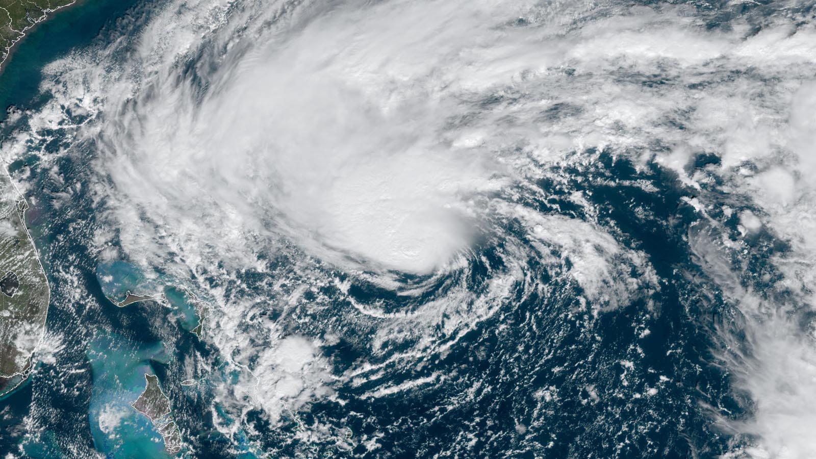
Check out this little pest. Possibility of criss-crossing the state and making landfall on both coasts. Some folks are still reeling from Ian, so the timing obviously sucks. And the media people get to show us their hype-games too.


Colleges
- AAC
- ACC
- Big 12
- Big East
- Big Ten
- Pac-12
- SEC
- Atlantic 10
- Conference USA
- Independents
- Junior College
- Mountain West
- Sun Belt
- MAC
- More
- Navy
- UAB
- Tulsa
- UTSA
- Charlotte
- Florida Atlantic
- Temple
- Rice
- East Carolina
- USF
- SMU
- North Texas
- Tulane
- Memphis
- Miami
- Louisville
- Virginia
- Syracuse
- Wake Forest
- Duke
- Boston College
- Virginia Tech
- Georgia Tech
- Pittsburgh
- North Carolina
- North Carolina State
- Clemson
- Florida State
- Cincinnati
- BYU
- Houston
- Iowa State
- Kansas State
- Kansas
- Texas
- Oklahoma State
- TCU
- Texas Tech
- Baylor
- Oklahoma
- UCF
- West Virginia
- Wisconsin
- Penn State
- Ohio State
- Purdue
- Minnesota
- Iowa
- Nebraska
- Illinois
- Indiana
- Rutgers
- Michigan State
- Maryland
- Michigan
- Northwestern
- Arizona State
- Oregon State
- UCLA
- Colorado
- Stanford
- Oregon
- Arizona
- California
- Washington
- USC
- Utah
- Washington State
- Texas A&M
- Auburn
- Mississippi State
- Kentucky
- South Carolina
- Arkansas
- Florida
- Missouri
- Ole Miss
- Alabama
- LSU
- Georgia
- Vanderbilt
- Tennessee
- Louisiana Tech
- New Mexico State
- Middle Tennessee
- Western Kentucky
- UTEP
- Florida International University
High School
- West
- Midwest
- Northeast
- Southeast
- Other
- Alaska
- Arizona
- California
- Colorado
- Nevada
- New Mexico
- Northern California
- Oregon
- Southern California Preps
- Washington
- Edgy Tim
- Indiana
- Kansas
- Nebraska
- Iowa
- Michigan
- Minnesota
- Missouri
- Oklahoma Varsity
- Texas Basketball
- Texas
- Wisconsin
- Delaware
- Maryland
- New Jersey Basketball
- New Jersey
- New York City Basketball
- Ohio
- Pennsylvania
- Greater Cincinnati
- Virginia
- West Virginia Preps
ADVERTISEMENT
Install the app
How to install the app on iOS
Follow along with the video below to see how to install our site as a web app on your home screen.
Note: This feature may not be available in some browsers.
You are using an out of date browser. It may not display this or other websites correctly.
You should upgrade or use an alternative browser.
You should upgrade or use an alternative browser.
Invest 98
- Thread starter FisherWilcoxTaggart Survivor
- Start date

We have just been put under a hurricane watch. Let the madness begin!
Weather Channel guys are enroute as we speak.We have just been put under a hurricane watch. Let the madness begin!
I hope they camp out on my front lawn!Weather Channel guys are enroute as we speak.
I just got one of those loud alerts on my phone and it’s a weather activation for a storm with a likely flooding surge. I live about 11 miles from the Jax Beach oceanfront and almost five miles from the St. John’s River so I’m not worried but we are being told to expect 10” of rain and 60 mph winds. Like a tropical depression or even a strong nor’easter.
Happy to see that as I am right on the hurricane warning/tropical storm warning line. But I still want a day off from work!Looks like the landfall track has shifted up north to around Fort Pierce.

I'm off Friday anyway but would prefer not to have a storm here that day. Who wants to stand in line at Golden Corral in the rain?Happy to see that as I am right on the hurricane warning/tropical storm warning line. But I still want a day off from work!
")
Darn it! We needed the rain here in Tally.Looks like the landfall track has shifted up north to around Fort Pierce.
Cape Coral is currently on a watch for winds around 25 mph, 1-3 " of rain, and about 2 feet of surge.
Can't decide whether to put the shutters back up for that.
Can't decide whether to put the shutters back up for that.
I think youll get rain in Tally if it stays on this track. Should be rain farther west as well.Darn it! We needed the rain here in Tally.
Tallahassee is showing the potential for some rain but none for the rest of the panhandle (currently).I think youll get rain in Tally if it stays on this track. Should be rain farther west as well.

Tally will get rain from this storm regardless. I am only concerned that the team flight might have delays getting out on Friday to Syracuse.Darn it! We needed the rain here in Tally.
I thought about that, but I've yet to see any models predicting weather sufficiently severe to inhibit air traffic at TLH.Tally will get rain from this storm regardless. I am only concerned that the team flight might have delays getting out on Friday to Syracuse.
They're playing the ominous music during forecasts on the 8's now... You guys better take this cereal.Weather Channel guys are enroute as we speak.
Under a hurricane warning now and still no word from corporate about the office closing tomorrow and Thursday. Don't think the Tri-rail will be running tomorrow so worst case I will work from home.
I like that channel as much as ESPN. Talk about weather hype.They're playing the ominous music during forecasts on the 8's now... You guys better take this cereal.

They're playing the ominous music during forecasts on the 8's now... You guys better take this cereal.
Which cereal? Wheaties? Cocoa Puffs? Inquiring minds want to know.

I like Boo Berry or Frankenberry myself.Which cereal? Wheaties? Cocoa Puffs? Inquiring minds want to know.
So, people come to your house to drop their drawers and bend over? Dayum!Under a hurricane warning now and still no word from corporate about the office closing tomorrow and Thursday. Don't think the Tri-rail will be running tomorrow so worst case I will work from home.
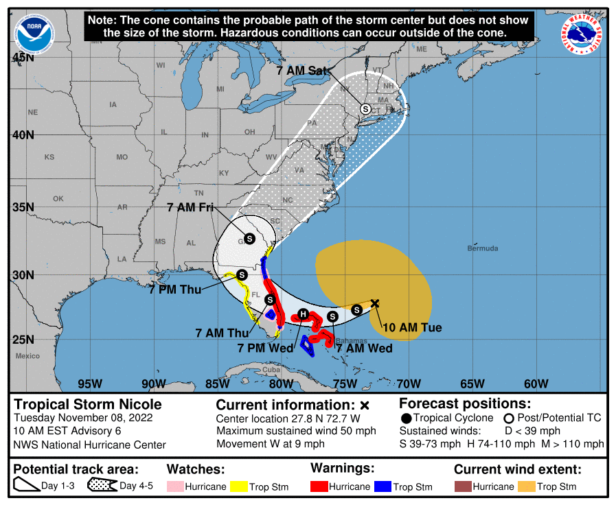
Tropical Storm Nicole intensifying as it heads towards the Bahamas and Florida » Yale Climate Connections
The large storm will bring impacts far to the north of its center, with coastal flooding expected all the way to North Carolina.
 yaleclimateconnections.org
when you are good, people will follow you anywhere!So, people come to your house to drop their drawers and bend over? Dayum!
I actually do like Cocoa Puffs... Cinnamon Life is my go-to though.Which cereal? Wheaties? Cocoa Puffs? Inquiring minds want to know.
GFS and Euro model now have it ticking farther west with rain bands impacting most of the panhandle.


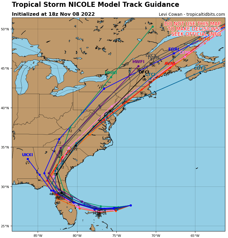
FSU meteorology grad - Dr Levi Cowan
Tuesday morning - Nicole to bring wide swath of impacts to Southeast U.S. and Bahamas
Tuesday morning - Nicole to bring wide swath of impacts to Southeast U.S. and Bahamas
Last edited:
It's looking better for you.Darn it! We needed the rain here in Tally.

You might even get a sprinkle over in your neck of the woods.It's looking better for you.


It’s already very windy here but the air is much cooler than a summer storm would be. Live pictures from the beaches are crazy. Seafoam is covering A1A in Vilano Beach
Similar threads
- Replies
- 6
- Views
- 165
- Replies
- 0
- Views
- 104
- Replies
- 2
- Views
- 222
ADVERTISEMENT
ADVERTISEMENT