

Colleges
- AAC
- ACC
- Big 12
- Big East
- Big Ten
- Pac-12
- SEC
- Atlantic 10
- Conference USA
- Independents
- Junior College
- Mountain West
- Sun Belt
- MAC
- More
- Navy
- UAB
- Tulsa
- UTSA
- Charlotte
- Florida Atlantic
- Temple
- Rice
- East Carolina
- USF
- SMU
- North Texas
- Tulane
- Memphis
- Miami
- Louisville
- Virginia
- Syracuse
- Wake Forest
- Duke
- Boston College
- Virginia Tech
- Georgia Tech
- Pittsburgh
- North Carolina
- North Carolina State
- Clemson
- Florida State
- Cincinnati
- BYU
- Houston
- Iowa State
- Kansas State
- Kansas
- Texas
- Oklahoma State
- TCU
- Texas Tech
- Baylor
- Oklahoma
- UCF
- West Virginia
- Wisconsin
- Penn State
- Ohio State
- Purdue
- Minnesota
- Iowa
- Nebraska
- Illinois
- Indiana
- Rutgers
- Michigan State
- Maryland
- Michigan
- Northwestern
- Arizona State
- Oregon State
- UCLA
- Colorado
- Stanford
- Oregon
- Arizona
- California
- Washington
- USC
- Utah
- Washington State
- Texas A&M
- Auburn
- Mississippi State
- Kentucky
- South Carolina
- Arkansas
- Florida
- Missouri
- Ole Miss
- Alabama
- LSU
- Georgia
- Vanderbilt
- Tennessee
- Louisiana Tech
- New Mexico State
- Middle Tennessee
- Western Kentucky
- UTEP
- Florida International University
High School
- West
- Midwest
- Northeast
- Southeast
- Other
- Alaska
- Arizona
- California
- Colorado
- Nevada
- New Mexico
- Northern California
- Oregon
- Southern California Preps
- Washington
- Edgy Tim
- Indiana
- Kansas
- Nebraska
- Iowa
- Michigan
- Minnesota
- Missouri
- Oklahoma Varsity
- Texas Basketball
- Texas
- Wisconsin
- Delaware
- Maryland
- New Jersey Basketball
- New Jersey
- New York City Basketball
- Ohio
- Pennsylvania
- Greater Cincinnati
- Virginia
- West Virginia Preps
ADVERTISEMENT
Install the app
How to install the app on iOS
Follow along with the video below to see how to install our site as a web app on your home screen.
Note: This feature may not be available in some browsers.
You are using an out of date browser. It may not display this or other websites correctly.
You should upgrade or use an alternative browser.
You should upgrade or use an alternative browser.
Keep an eye on Inv 97L (Now Hurricane Matthew)
- Thread starter Fijimn
- Start date
Haiti is now getting battered by Matthew.... I added the Guantanamo Bay radar and IR satellite images on my site: https://www.tropicalweather.net/hurricane-and-travel-message-board/viewforum.php?f=85


I'm surprised that the coast of Florida doesn't have at least watches.
I'm surprised that the coast of Florida doesn't have at least watches.
I think Palm Beach County north is under a hurricane watch, while Broward and Miami are under tropical storm watches.
A man jumped from the 10th story and is falling to the ground. A woman at the 4th floor sees him from her window and asks, "Hey, how's it going?". The man replies "So far, so good."

I'm surprised that the coast of Florida doesn't have at least watches.
Hurricane watches are issued 48 hours in advance of the anticipated tropical storm force winds.
I've read there maybe some shifts at 500 in the cone. Are the models shifting that far west?Hurricane watches are issued 48 hours in advance of the anticipated tropical storm force winds.
I've read there maybe some shifts at 500 in the cone. Are the models shifting that far west?
Don't shift west. Don't shift west...
So friends of ours are scheduled to leave Miami on a cruise Saturday morning. Wonder if they postpone their departure.
Will be long gone from Miami by Saturday. My guess would be beautiful weather. Now what the ports of call look like...
Not DeFuniak Springs Country Club west!Don't shift west. Don't shift west...
Correct me if I'm wrong, but if this thing hits Jax, it will be Saturday, correct?
My FIL wants to drive from Tally to pick up my daughter (no pics) at UNF tomorrow.
My FIL wants to drive from Tally to pick up my daughter (no pics) at UNF tomorrow.
Correct me if I'm wrong, but if this thing hits Jax, it will be Saturday, correct?
My FIL wants to drive from Tally to pick up my daughter (no pics) at UNF tomorrow.
Will be in NC by Saturday. Would be gorgeous weather in Jax. Time to leave Jax, if you're going to leave, is Wednesday or Thursday morning.
That sounds like a good idea.Correct me if I'm wrong, but if this thing hits Jax, it will be Saturday, correct?
My FIL wants to drive from Tally to pick up my daughter (no pics) at UNF tomorrow.
Get in and out before the exodus leaves, if there is an evacuation.
I-10 turned into one way west would not be a pretty sight to behold. Almost as bad as I-95 as one way north. (Wish that would stay after the storm)
All the cruise ships will be West of I95Will be long gone from Miami by Saturday. My guess would be beautiful weather. Now what the ports of call look like...
The time to bug out if you're gonna leave is early tomorrow and secure a hotel now. Heard horror stories of traffic jams on 95, 75, 4, and 10 during Floyd. And that sucker curved away at the last minute. Im gonna ride this motha out.
Track forecast for Matthew
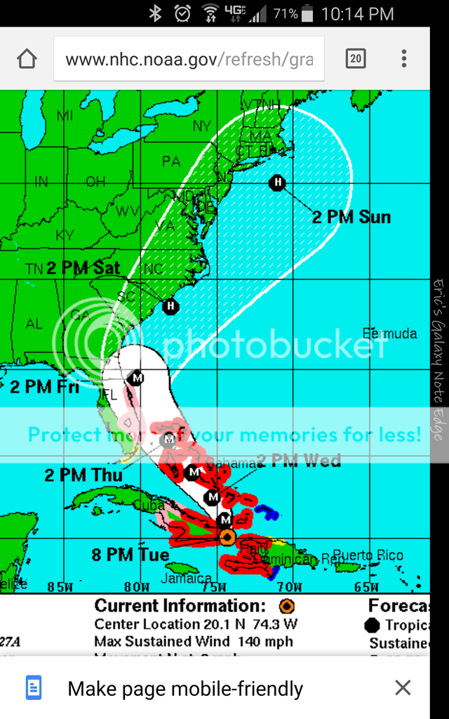
The significant westward shift in computer model guidance on Hurricane Matthew that occurred yesterday is holding, and we now have increased confidence that Matthew will bring severe impacts to the Southeast U.S. coast from South Florida to Cape Hatteras, North Carolina.
Matthew will continue northwards after clearing the southwest tip of Haiti Tuesday morning, then make a second landfall in eastern Cuba at about 6 pm EDT Tuesday. Matthew will turn north-northwest and then northwest on Wednesday, and traverse The Bahamas from southeast to northwest Wednesday morning through Thursday morning. In their 5 am EDT Tuesday Wind Probability Forecast, NHC gave highest odds of hurricane-force winds in The Bahamas to Great Exuma (57%), New Providence (46%), and Grand Bahama (37%).
Late Thursday morning, Matthew will be very close to the coast of South Florida, and is expected to turn more to the north-northwest, almost parallel to the coast, at that time. The latest 00Z and 06Z Tuesday runs of our top two models for predicting hurricane tracks—the GFS and European models—did not show a Florida landfall, but brought the hurricane so close to Florida—within 50 miles—that most of the coast of Florida from West Palm Beach to Daytona Beach would experience sustained winds of at least 50 mph, if these forecasts verified. Keep in mind that the diameter of NHC’s cone of uncertainty two days into the future is about 100 miles; the cone is about 130 miles across three days into the future. On average, about two-thirds of all hurricanes stay within the cone, but some hurricanes are tougher to predict than others, and Matthew certainly falls into that category. Thus, it would not be a surprise to see Matthew make landfall in Florida. Two of the four members of the Euro “high-probability” cluster--the ensemble forecasts that most closely match the operational run--depicted Matthew making landfall on Florida’s East Coast near West Palm Beach on Thursday. In their 5 am EDT Tuesday Wind Probability Forecast, NHC gave highest odds of hurricane-force winds in Florida to Ft. Pierce (22%), West Palm Beach (21%), and Cocoa Beach (19%). Update: At 11 am EDT Tuesday, NHC placed the Florida coast from Deerfield Beach to the Volusia/Brevard county line under a Hurricane Watch, with a Tropical Storm Watch in effect southward from south of Deerfield Beach to the Seven Mile Bridge in the Florida Keys, including Lake Okeechobee.
https://www.wunderground.com/blog/J...s-haiti-their-strongest-hurricane-in-52-years

The surfer dudes be watching......Expecting some of this.
Not this one, too close. It'll be a washing machine until it passes and then flat as a lake once the backside offshores move in.
He is saying that everything looks good now... but watch out for the landing.^^^ Ummm...what? ^^^
Did you mean to post that in this thread?
Hope they bought the travel insurance.So friends of ours are scheduled to leave Miami on a cruise Saturday morning. Wonder if they postpone their departure.
Will be in NC by Saturday. Would be gorgeous weather in Jax. Time to leave Jax, if you're going to leave, is Wednesday or Thursday morning.
My in laws live in South Ponte Vedra right close to the border with Vilano Beach, about two miles north of Caps. They're bugging out of the island tomorrow afternoon and coming to our house.
We're in Northern St Johns but not in a flood plain or evac zone. We're going to stock up and hope this bastard shifts east.
Good luck. After 5 days without power last month, I've changed my mind on when I leave or stay.
Late news on Channel 25 tonight skirted around the word catastrophic ...Moving west and north. Jacksonville right in the cross hairs.

Thanks - I am slow.He is saying that everything looks good now... but watch out for the landing.
I know the ACC is watching this closely. Wonder what the time frame is for making a decision on the game. The storm will be gone but there's a good chance the area will be in recovery mode.
The thing is the team would have to travel down into a hurricane and a state of emergency area. I just don't see how they could let them do that.I know the ACC is watching this closely. Wonder what the time frame is for making a decision on the game. The storm will be gone but there's a good chance the area will be in recovery mode.
Both of the models are now showing a loop back south. The ridge builds to the north stalling it near South Carolina before sending it back south / southwest Sunday into next week.
Similar threads
- Replies
- 0
- Views
- 360
- Replies
- 20
- Views
- 727
- Replies
- 0
- Views
- 530
- Replies
- 2
- Views
- 450
ADVERTISEMENT
Latest posts
-
-

-
 Softball FSU honors seniors, sweeps UNC, picks up 14th straight win
- Latest: Bob Ferrante
-

ADVERTISEMENT