

Colleges
- AAC
- ACC
- Big 12
- Big East
- Big Ten
- Pac-12
- SEC
- Atlantic 10
- Conference USA
- Independents
- Junior College
- Mountain West
- Sun Belt
- MAC
- More
- Navy
- UAB
- Tulsa
- UTSA
- Charlotte
- Florida Atlantic
- Temple
- Rice
- East Carolina
- USF
- SMU
- North Texas
- Tulane
- Memphis
- Miami
- Louisville
- Virginia
- Syracuse
- Wake Forest
- Duke
- Boston College
- Virginia Tech
- Georgia Tech
- Pittsburgh
- North Carolina
- North Carolina State
- Clemson
- Florida State
- Cincinnati
- BYU
- Houston
- Iowa State
- Kansas State
- Kansas
- Texas
- Oklahoma State
- TCU
- Texas Tech
- Baylor
- Oklahoma
- UCF
- West Virginia
- Wisconsin
- Penn State
- Ohio State
- Purdue
- Minnesota
- Iowa
- Nebraska
- Illinois
- Indiana
- Rutgers
- Michigan State
- Maryland
- Michigan
- Northwestern
- Arizona State
- Oregon State
- UCLA
- Colorado
- Stanford
- Oregon
- Arizona
- California
- Washington
- USC
- Utah
- Washington State
- Texas A&M
- Auburn
- Mississippi State
- Kentucky
- South Carolina
- Arkansas
- Florida
- Missouri
- Ole Miss
- Alabama
- LSU
- Georgia
- Vanderbilt
- Tennessee
- Louisiana Tech
- New Mexico State
- Middle Tennessee
- Western Kentucky
- UTEP
- Florida International University
High School
- West
- Midwest
- Northeast
- Southeast
- Other
- Alaska
- Arizona
- California
- Colorado
- Nevada
- New Mexico
- Northern California
- Oregon
- Southern California Preps
- Washington
- Edgy Tim
- Indiana
- Kansas
- Nebraska
- Iowa
- Michigan
- Minnesota
- Missouri
- Oklahoma Varsity
- Texas Basketball
- Texas
- Wisconsin
- Delaware
- Maryland
- New Jersey Basketball
- New Jersey
- New York City Basketball
- Ohio
- Pennsylvania
- Greater Cincinnati
- Virginia
- West Virginia Preps
ADVERTISEMENT
Install the app
How to install the app on iOS
Follow along with the video below to see how to install our site as a web app on your home screen.
Note: This feature may not be available in some browsers.
You are using an out of date browser. It may not display this or other websites correctly.
You should upgrade or use an alternative browser.
You should upgrade or use an alternative browser.
Hurricane Irma
- Thread starter Fijimn
- Start date
The five day forecast has it kind of low to hit South Florida. Hope it stays down there.

The five day forecast has it kind of low to hit South Florida. Hope it stays down there.
Looks like it's going to see if it can get to Houston.

Having grown up in Panama City, I've been an avid follower of tropical cyclones since childhood. I can assure you that this one is serious. The strongest cane ever to strike the U.S. was Camille back in '69, and it began the same way Irma has.
Having grown up in Panama City, I've been an avid follower of tropical cyclones since childhood. I can assure you that this one is serious. The strongest cane ever to strike the U.S. was Camille back in '69, and it began the same way Irma has.
Funny you say that. My dad (lived in panhandle only since 85) was always more concerned about the late year ones that start in the Gulf and go NE vs the lows coming over the islands.
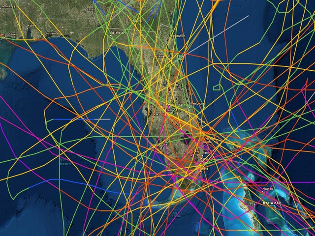
NOAA hundred year chart of FL hurricane landfalls.
Cat 2 Irma Rapidly Intensifying in Eastern Atlantic; Big Long-Range Questions
Dr. Jeff Masters · August 31, 2017, 2:20 PM
Here comes trouble. Hurricane Irma built an eyewall over the warm waters of the Eastern Atlantic on Thursday morning, and is now rapidly intensifying, becoming a Category 2 hurricane with 100 mph winds at 11 am EDT. Irma is the fourth hurricane of this active Atlantic hurricane season, and comes three weeks before the usual September 21 date for the season's fourth hurricane. Irma appears destined to become a dangerous long-track major hurricane that could potentially impact the islands of the Caribbean as well as the mainland U.S. next week and the following week.
Satellite images on Thursday morning showed a well-organized storm with plenty of heavy thunderstorms which were increasing in intensity, and a prominent eye had appeared in both visible and infrared imagery. Irma had a respectable upper-level outflow channel to the south, and a weaker one to the north. Conditions were favorable for development, with sea surface temperatures (SSTs) near 27.5°C (82°F)—more than 1°C above average, light wind shear of 5 -10 knots, and a moist surrounding atmosphere with a mid-level relative humidity near 65%.
Intensity forecast for Irma
For the next five days, wind shear is predicted to be very favorable for development--a low 5 – 10 knots--according to the 12Z Thursday run of the SHIPS model. In fact, SHIPS keeps wind shear at less than 5 knots from Thursday afternoon into Saturday. Irma will begin moving into a drier region with slightly cooler sea surface temperatures beginning on Thursday night. Friday through Sunday, SSTs will be 26.5 – 27.5°C (80 - 82°F), and the mid-level relative humidity will be 50 – 55%--conditions that are less favorable for development. Since Irma has already built a solid inner core, it should be able to overcome these less favorable conditions and continue to intensify at a slow to moderate pace. If the storm can develop upper-level outflow channels to both the north and the south, faster intensification may occur.
Early next week, when Irma will be approaching the Lesser Antilles Islands, SSTs will warm considerably with a major increase in total heat content. The atmosphere is also predicted to be moister with low shear, so increased strengthening is likely. Four out of five of our reliable intensity models--the HWRF, LGEM, COAMPS-TC, and DSHIPS--predicted in their 6Z and 12Z Thursday runs that Irma would be a major Category 3 or 4 hurricane with 115 – 135 mph winds by Tuesday. The official NHC forecast of a Category 4 hurricane in five days looks reasonable, given Irma's current rapid intensification burst.
Track forecast for Irma
Irma will head generally west to west-northwest at about 10 mph through Friday, then assume a more west-southwesterly track early next week, as the ridge of high pressure steering the storm builds to the southwest. This would potentially bring Irma into the Lesser Antilles Islands as early as Tuesday night, September 5, as predicted by the 0Z Thursday run of the European model. The 0Z and 6Z GFS model solutions were slower, predicting that Irma would make its closest approach to the Lesser Antilles Islands on Wednesday night, but miss the islands, passing about 500 miles to the northeast. The 0Z Thursday run of the UKMET model split the difference between these forecasts, forecasting that Irma would pass within 200 miles of the northernmost Lesser Antilles Islands on Wednesday morning.
To get a better sense of where Irma might go, it is often helpful to look at the ensemble forecasts from the European and GFS models. These forecasts take the operational high-resolution version of the models and impose slight variations in the initial atmospheric conditions, to simulate an ensemble of potential outcomes. They are run at lower resolution, so individual ensemble members are likely to be less reliable than the operational version. The GFS model runs 20 different ensemble forecasts, and the European model runs 50. One tool that I have found valuable is to look at the “high probability cluster” of the European model—the four ensemble members that have done the best job tracking Irma over the past day. Looking at Figure 2, the high probability cluster predicts that the Caribbean and U.S. Gulf Coast might be the most at-risk areas for a landfall by Irma.
Bottom line: Climatology is in Irma's favor. We are fast approaching the average peak date of the Atlantic hurricane season (September 10) as well as the seasonal peak of African tropical waves. Moreover, SSTs are above seasonal averages across the entire tropical Atlantic. Irma is more than a week away from any possible U.S. impacts. Bear in mind that, on average, long-range hurricane forecasts beyond 7 days have very little skill when it comes to specific locations and intensities, and much could change in the coming days. The idea is not to take a particular track or strength forecast as gospel at this point, but to be aware that a major hurricane could be approaching North America in the 1- to 2-week time frame.
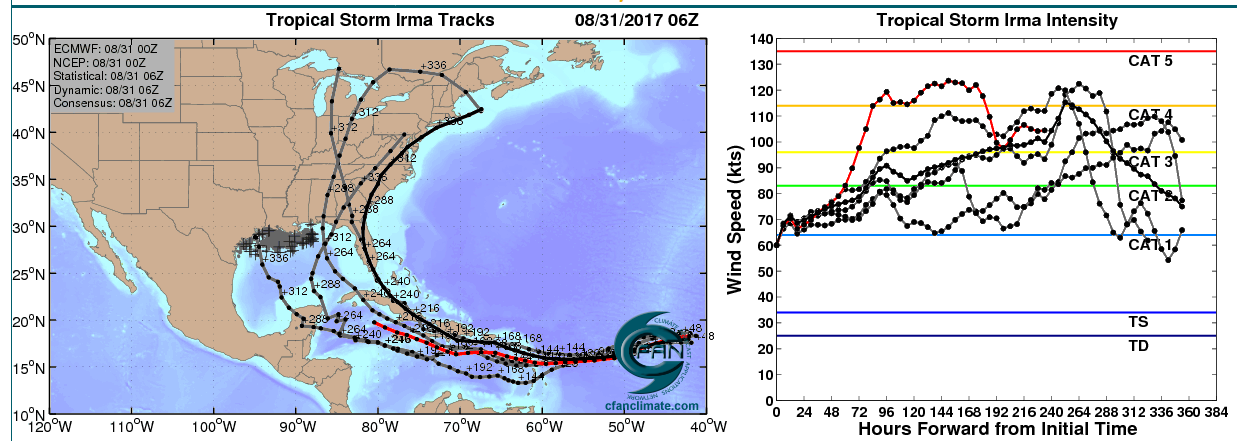
Figure 2. Left: The adjusted 0Z August 31, 2017 track forecast by the operational European model for Irma (red line), along with the track of the average of the 50 members of the European model ensemble (heavy black line), and the track forecasts from the “high probability cluster” (grey lines)—the four European model ensemble members that have performed best with Irma thus far, as of 6Z Thursday. Right: the corresponding intensity forecast for these various model runs, with the operational European model forecast shown in red. All of the forecasts take Irma to major hurricane status at some point in the next 12 days. Irma is much stronger than the 0Z run had anticipated, so the intenisty forecast is likely underdone. Image credit: CFAN.
https://www.wunderground.com/cat6/irma-intensifying-eastern-atlantic-big-long-range-questions
Dr. Jeff Masters · August 31, 2017, 2:20 PM
Here comes trouble. Hurricane Irma built an eyewall over the warm waters of the Eastern Atlantic on Thursday morning, and is now rapidly intensifying, becoming a Category 2 hurricane with 100 mph winds at 11 am EDT. Irma is the fourth hurricane of this active Atlantic hurricane season, and comes three weeks before the usual September 21 date for the season's fourth hurricane. Irma appears destined to become a dangerous long-track major hurricane that could potentially impact the islands of the Caribbean as well as the mainland U.S. next week and the following week.
Satellite images on Thursday morning showed a well-organized storm with plenty of heavy thunderstorms which were increasing in intensity, and a prominent eye had appeared in both visible and infrared imagery. Irma had a respectable upper-level outflow channel to the south, and a weaker one to the north. Conditions were favorable for development, with sea surface temperatures (SSTs) near 27.5°C (82°F)—more than 1°C above average, light wind shear of 5 -10 knots, and a moist surrounding atmosphere with a mid-level relative humidity near 65%.
Intensity forecast for Irma
For the next five days, wind shear is predicted to be very favorable for development--a low 5 – 10 knots--according to the 12Z Thursday run of the SHIPS model. In fact, SHIPS keeps wind shear at less than 5 knots from Thursday afternoon into Saturday. Irma will begin moving into a drier region with slightly cooler sea surface temperatures beginning on Thursday night. Friday through Sunday, SSTs will be 26.5 – 27.5°C (80 - 82°F), and the mid-level relative humidity will be 50 – 55%--conditions that are less favorable for development. Since Irma has already built a solid inner core, it should be able to overcome these less favorable conditions and continue to intensify at a slow to moderate pace. If the storm can develop upper-level outflow channels to both the north and the south, faster intensification may occur.
Early next week, when Irma will be approaching the Lesser Antilles Islands, SSTs will warm considerably with a major increase in total heat content. The atmosphere is also predicted to be moister with low shear, so increased strengthening is likely. Four out of five of our reliable intensity models--the HWRF, LGEM, COAMPS-TC, and DSHIPS--predicted in their 6Z and 12Z Thursday runs that Irma would be a major Category 3 or 4 hurricane with 115 – 135 mph winds by Tuesday. The official NHC forecast of a Category 4 hurricane in five days looks reasonable, given Irma's current rapid intensification burst.
Track forecast for Irma
Irma will head generally west to west-northwest at about 10 mph through Friday, then assume a more west-southwesterly track early next week, as the ridge of high pressure steering the storm builds to the southwest. This would potentially bring Irma into the Lesser Antilles Islands as early as Tuesday night, September 5, as predicted by the 0Z Thursday run of the European model. The 0Z and 6Z GFS model solutions were slower, predicting that Irma would make its closest approach to the Lesser Antilles Islands on Wednesday night, but miss the islands, passing about 500 miles to the northeast. The 0Z Thursday run of the UKMET model split the difference between these forecasts, forecasting that Irma would pass within 200 miles of the northernmost Lesser Antilles Islands on Wednesday morning.
To get a better sense of where Irma might go, it is often helpful to look at the ensemble forecasts from the European and GFS models. These forecasts take the operational high-resolution version of the models and impose slight variations in the initial atmospheric conditions, to simulate an ensemble of potential outcomes. They are run at lower resolution, so individual ensemble members are likely to be less reliable than the operational version. The GFS model runs 20 different ensemble forecasts, and the European model runs 50. One tool that I have found valuable is to look at the “high probability cluster” of the European model—the four ensemble members that have done the best job tracking Irma over the past day. Looking at Figure 2, the high probability cluster predicts that the Caribbean and U.S. Gulf Coast might be the most at-risk areas for a landfall by Irma.
Bottom line: Climatology is in Irma's favor. We are fast approaching the average peak date of the Atlantic hurricane season (September 10) as well as the seasonal peak of African tropical waves. Moreover, SSTs are above seasonal averages across the entire tropical Atlantic. Irma is more than a week away from any possible U.S. impacts. Bear in mind that, on average, long-range hurricane forecasts beyond 7 days have very little skill when it comes to specific locations and intensities, and much could change in the coming days. The idea is not to take a particular track or strength forecast as gospel at this point, but to be aware that a major hurricane could be approaching North America in the 1- to 2-week time frame.
Figure 2. Left: The adjusted 0Z August 31, 2017 track forecast by the operational European model for Irma (red line), along with the track of the average of the 50 members of the European model ensemble (heavy black line), and the track forecasts from the “high probability cluster” (grey lines)—the four European model ensemble members that have performed best with Irma thus far, as of 6Z Thursday. Right: the corresponding intensity forecast for these various model runs, with the operational European model forecast shown in red. All of the forecasts take Irma to major hurricane status at some point in the next 12 days. Irma is much stronger than the 0Z run had anticipated, so the intenisty forecast is likely underdone. Image credit: CFAN.
https://www.wunderground.com/cat6/irma-intensifying-eastern-atlantic-big-long-range-questions
We've all seen just how devastating a storm that starts in the Gulf can be just this past week.Funny you say that. My dad (lived in panhandle only since 85) was always more concerned about the late year ones that start in the Gulf and go NE vs the lows coming over the islands.
NOAA hundred year chart of FL hurricane landfalls.
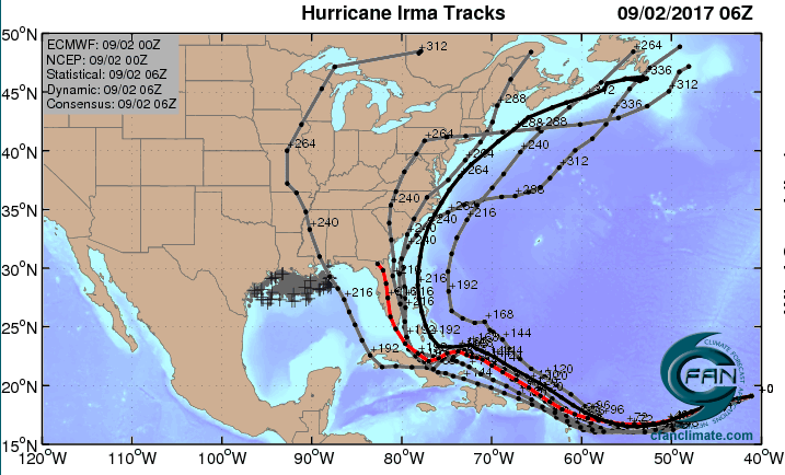
We missed you in the Harvey thread Chimp.GFS has been turning it north ahead of the Islands and generally east of the US. The Euro has been farther south. The timing and strength of the upper troughs can be very tricky. Many times the solution ends up being a combination of the two models.
Don't be talking that stuff. Got a place in Mexico BeachHaving grown up in Panama City, I've been an avid follower of tropical cyclones since childhood. I can assure you that this one is serious. The strongest cane ever to strike the U.S. was Camille back in '69, and it began the same way Irma has.
Funny you say that. My dad (lived in panhandle only since 85) was always more concerned about the late year ones that start in the Gulf and go NE vs the lows coming over the islands.
NOAA hundred year chart of FL hurricane landfalls.
Looks like my table cloth the last time I went to Macaroni Grill and had to wait forever for my food.
That guy could never work for the Weather Channel. There was absolutely no panic in his voice.
A lot of the storms that get real strong, real quick and are that far out fizzle out
Thankfully!
Now DFS, I live in south Florida don't send that crap this way
Thankfully!
Now DFS, I live in south Florida don't send that crap this way
I spent my first 40 years in WPB. Still have family there. Not trying to put the target on you.A lot of the storms that get real strong, real quick and are that far out fizzle out
Thankfully!
Now DFS, I live in south Florida don't send that crap this way
This is likely a fish storm. Gonna turn north.
We all pray you are right.
The projected intensity (which is a guessing game this far out) puts it as the strongest storm ever seen in the Atlantic. I hope you are right
You are not in the majority with that opinion.This is likely a fish storm. Gonna turn north.
I am leaving on a cruise Saturday out of Tampa for 5 nights with stops in Grand Cayman and Cozumel. Hoping for calm seas.
Good luck Mike.I am leaving on a cruise Saturday out of Tampa for 5 nights with stops in Grand Cayman and Cozumel. Hoping for calm seas.
Thanks, Mom. Of more importace is that I don't need a reason to jump overboard after the game Saturday night
I had the late shift so I was working / sleeping the last several days.We missed you in the Harvey thread Chimp.
Cat 2 Irma Rapidly Intensifying in Eastern Atlantic; Big Long-Range Questions
Dr. Jeff Masters · August 31, 2017, 2:20 PM
Here comes trouble. Hurricane Irma built an eyewall over the warm waters of the Eastern Atlantic on Thursday morning, and is now rapidly intensifying, becoming a Category 2 hurricane with 100 mph winds at 11 am EDT. Irma is the fourth hurricane of this active Atlantic hurricane season, and comes three weeks before the usual September 21 date for the season's fourth hurricane. Irma appears destined to become a dangerous long-track major hurricane that could potentially impact the islands of the Caribbean as well as the mainland U.S. next week and the following week.
Satellite images on Thursday morning showed a well-organized storm with plenty of heavy thunderstorms which were increasing in intensity, and a prominent eye had appeared in both visible and infrared imagery. Irma had a respectable upper-level outflow channel to the south, and a weaker one to the north. Conditions were favorable for development, with sea surface temperatures (SSTs) near 27.5°C (82°F)—more than 1°C above average, light wind shear of 5 -10 knots, and a moist surrounding atmosphere with a mid-level relative humidity near 65%.
Intensity forecast for Irma
For the next five days, wind shear is predicted to be very favorable for development--a low 5 – 10 knots--according to the 12Z Thursday run of the SHIPS model. In fact, SHIPS keeps wind shear at less than 5 knots from Thursday afternoon into Saturday. Irma will begin moving into a drier region with slightly cooler sea surface temperatures beginning on Thursday night. Friday through Sunday, SSTs will be 26.5 – 27.5°C (80 - 82°F), and the mid-level relative humidity will be 50 – 55%--conditions that are less favorable for development. Since Irma has already built a solid inner core, it should be able to overcome these less favorable conditions and continue to intensify at a slow to moderate pace. If the storm can develop upper-level outflow channels to both the north and the south, faster intensification may occur.
Early next week, when Irma will be approaching the Lesser Antilles Islands, SSTs will warm considerably with a major increase in total heat content. The atmosphere is also predicted to be moister with low shear, so increased strengthening is likely. Four out of five of our reliable intensity models--the HWRF, LGEM, COAMPS-TC, and DSHIPS--predicted in their 6Z and 12Z Thursday runs that Irma would be a major Category 3 or 4 hurricane with 115 – 135 mph winds by Tuesday. The official NHC forecast of a Category 4 hurricane in five days looks reasonable, given Irma's current rapid intensification burst.
Track forecast for Irma
Irma will head generally west to west-northwest at about 10 mph through Friday, then assume a more west-southwesterly track early next week, as the ridge of high pressure steering the storm builds to the southwest. This would potentially bring Irma into the Lesser Antilles Islands as early as Tuesday night, September 5, as predicted by the 0Z Thursday run of the European model. The 0Z and 6Z GFS model solutions were slower, predicting that Irma would make its closest approach to the Lesser Antilles Islands on Wednesday night, but miss the islands, passing about 500 miles to the northeast. The 0Z Thursday run of the UKMET model split the difference between these forecasts, forecasting that Irma would pass within 200 miles of the northernmost Lesser Antilles Islands on Wednesday morning.
To get a better sense of where Irma might go, it is often helpful to look at the ensemble forecasts from the European and GFS models. These forecasts take the operational high-resolution version of the models and impose slight variations in the initial atmospheric conditions, to simulate an ensemble of potential outcomes. They are run at lower resolution, so individual ensemble members are likely to be less reliable than the operational version. The GFS model runs 20 different ensemble forecasts, and the European model runs 50. One tool that I have found valuable is to look at the “high probability cluster” of the European model—the four ensemble members that have done the best job tracking Irma over the past day. Looking at Figure 2, the high probability cluster predicts that the Caribbean and U.S. Gulf Coast might be the most at-risk areas for a landfall by Irma.
Bottom line: Climatology is in Irma's favor. We are fast approaching the average peak date of the Atlantic hurricane season (September 10) as well as the seasonal peak of African tropical waves. Moreover, SSTs are above seasonal averages across the entire tropical Atlantic. Irma is more than a week away from any possible U.S. impacts. Bear in mind that, on average, long-range hurricane forecasts beyond 7 days have very little skill when it comes to specific locations and intensities, and much could change in the coming days. The idea is not to take a particular track or strength forecast as gospel at this point, but to be aware that a major hurricane could be approaching North America in the 1- to 2-week time frame.
Figure 2. Left: The adjusted 0Z August 31, 2017 track forecast by the operational European model for Irma (red line), along with the track of the average of the 50 members of the European model ensemble (heavy black line), and the track forecasts from the “high probability cluster” (grey lines)—the four European model ensemble members that have performed best with Irma thus far, as of 6Z Thursday. Right: the corresponding intensity forecast for these various model runs, with the operational European model forecast shown in red. All of the forecasts take Irma to major hurricane status at some point in the next 12 days. Irma is much stronger than the 0Z run had anticipated, so the intenisty forecast is likely underdone. Image credit: CFAN.
https://www.wunderground.com/cat6/irma-intensifying-eastern-atlantic-big-long-range-questions
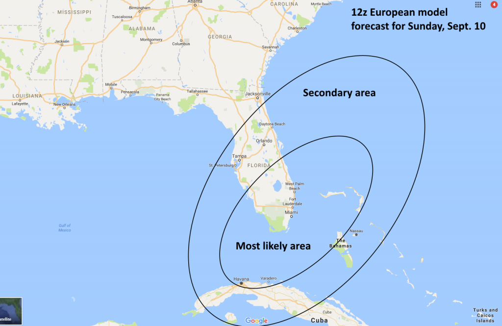
The paths shown here are NOT good....hoping for a serious deviation.

Everything I'm reading says it's WAY too early to tell what it's going to do. This appears to show it being highly likely to go up/toward the Atlantic Coast. Let's hope your chart maker(s) know something everyone else doesn't!
It's 3,000 miles away. It'll be at least a week before any predictions can be somewhat accurate.
Everyone relax your hurricane prediction sphincters before you give goldmom anxiety unnecessarily!
Everyone relax your hurricane prediction sphincters before you give goldmom anxiety unnecessarily!
I am leaving on a cruise Saturday out of Tampa for 5 nights with stops in Grand Cayman and Cozumel. Hoping for calm seas.
When suppertime came, the old cook came on deck sayin'
Fellas, it's too rough to feed ya
At seven pm a main hatchway caved in, he said
Fellas, it's been good t'know ya
I think that's the idea. Those of us who have lived in hurricane-prone areas for decades can tend to become jaded and be susceptible to being caught with our proverbial pants down (no pics). We panhandle-dwelling veterans are simply trying to sound the alarm to keep an eye on something we actually deem serious.
Stop it!! You're scaring me.
Looks a lot like the way Andrew startedThe five day forecast has it kind of low to hit South Florida. Hope it stays down there.
5 day cone starting to bend it north. Hope that trend continues and it bends back to sea.

Similar threads
- Replies
- 2
- Views
- 124
- Replies
- 0
- Views
- 90
- Replies
- 6
- Views
- 562
- Replies
- 2
- Views
- 658
ADVERTISEMENT
Latest posts
-

-
-
-

-
 Softball FSU honors seniors, sweeps UNC, picks up 14th straight win
- Latest: Bob Ferrante
ADVERTISEMENT