Thanks Squiffy. Was wondering what they did with students during a storm. Fingers crossed my daughter (no pics) will be there next year.
Colleges
- American Athletic
- Atlantic Coast
- Big 12
- Big East
- Big Ten
- Colonial
- Conference USA
- Independents (FBS)
- Junior College
- Mountain West
- Northeast
- Pac-12
- Patriot League
- Pioneer League
- Southeastern
- Sun Belt
- Army
- Charlotte
- East Carolina
- Florida Atlantic
- Memphis
- Navy
- North Texas
- Rice
- South Florida
- Temple
- Tulane
- Tulsa
- UAB
- UTSA
- Boston College
- California
- Clemson
- Duke
- Florida State
- Georgia Tech
- Louisville
- Miami (FL)
- North Carolina
- North Carolina State
- Pittsburgh
- Southern Methodist
- Stanford
- Syracuse
- Virginia
- Virginia Tech
- Wake Forest
- Arizona
- Arizona State
- Baylor
- Brigham Young
- Cincinnati
- Colorado
- Houston
- Iowa State
- Kansas
- Kansas State
- Oklahoma State
- TCU
- Texas Tech
- UCF
- Utah
- West Virginia
- Illinois
- Indiana
- Iowa
- Maryland
- Michigan
- Michigan State
- Minnesota
- Nebraska
- Northwestern
- Ohio State
- Oregon
- Penn State
- Purdue
- Rutgers
- UCLA
- USC
- Washington
- Wisconsin
High Schools
- Illinois HS Sports
- Indiana HS Sports
- Iowa HS Sports
- Kansas HS Sports
- Michigan HS Sports
- Minnesota HS Sports
- Missouri HS Sports
- Nebraska HS Sports
- Oklahoma HS Sports
- Texas HS Hoops
- Texas HS Sports
- Wisconsin HS Sports
- Cincinnati HS Sports
- Delaware
- Maryland HS Sports
- New Jersey HS Hoops
- New Jersey HS Sports
- NYC HS Hoops
- Ohio HS Sports
- Pennsylvania HS Sports
- Virginia HS Sports
- West Virginia HS Sports
ADVERTISEMENT
You are using an out of date browser. It may not display this or other websites correctly.
You should upgrade or use an alternative browser.
You should upgrade or use an alternative browser.
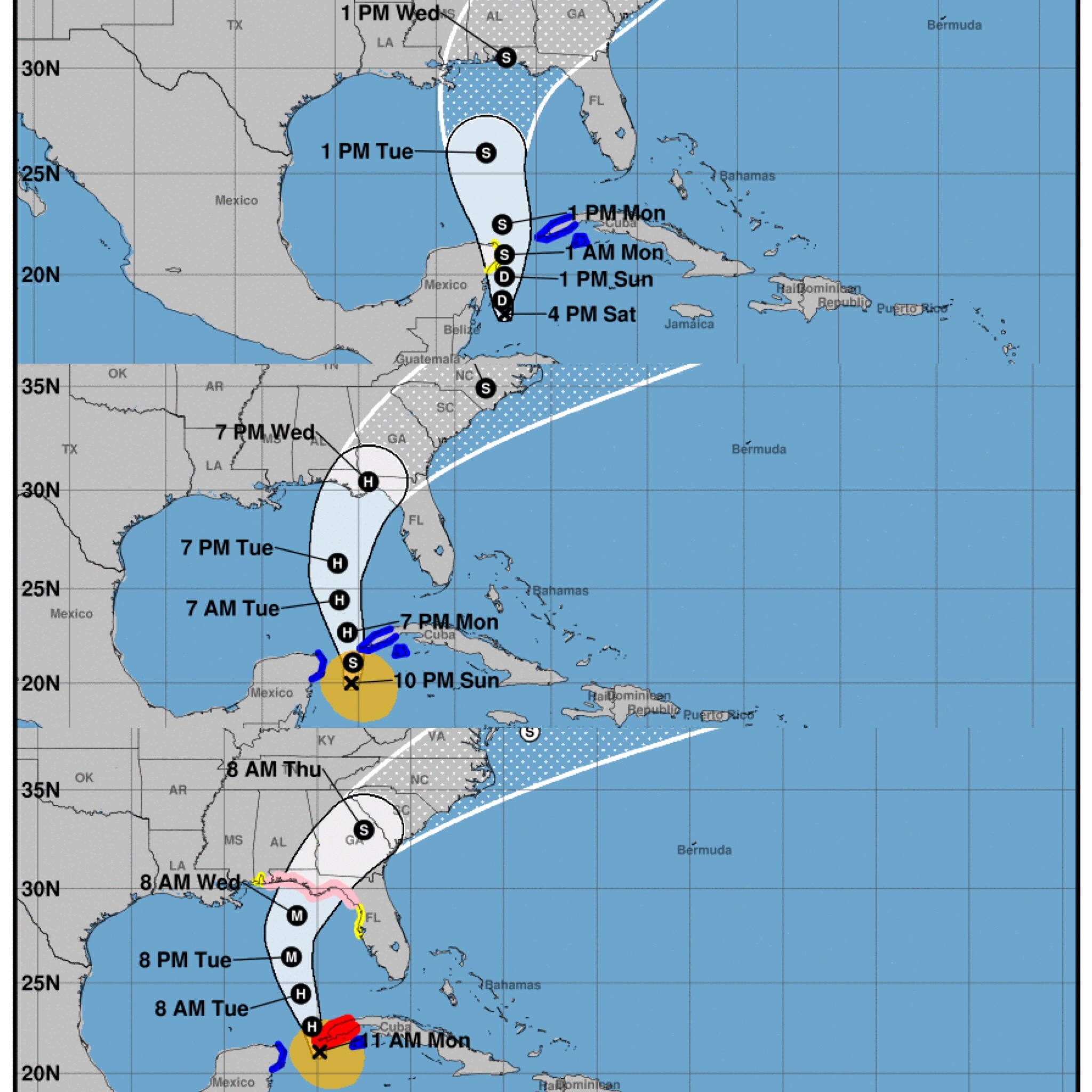
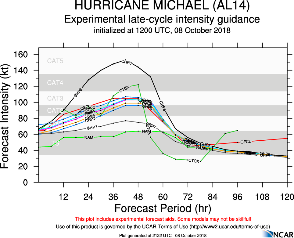
Now Cat 4 Michael
- Thread starter DFSNOLE
- Start date
Nope, they just fly straight through them.OK, in true lockerroom spirit, here's a dumb question: I'm supposed to fly home to Nashville from Tampa on 9 PM Wednesday night, which would likely place my flight path over the storm. Do commercial airliners typically alter their flight path, fly over the storm or cancel the flight altogether?
If you see Jim Cantore, I suggest you leave town.
Someone should investigate Mr. Cantore. He seems to leave a trail of destruction wherever he travels.If you see Jim Cantore, I suggest you leave town.
If you see Jim Cantore, I suggest you leave town.
I actually saw a picture of him at the Tallahassee Airport.
I actually saw a picture of him at the Tallahassee Airport.
Just found out that I'm on 12 hour shifts at our EOC. Yay.
I hope this extra workload doesn't impede on any possible bans in the Locker Room...not that I'm thinking of anyone in particular.
I'll have to find something to do during the down times.I hope this extra workload doesn't impede on any possible bans in the Locker Room...not that I'm thinking of anyone in particular.
FSU cancelled classes Tuesday through Thursday...(I think). My kids are planning to head home tomorrow morning...already gassed up the cars....Both of them have jobs and both jobs are telling them they need to be at work. We shall see.
I believe FSU, TCC, and Leon County Schools all closed through the whole week, re-opening on Monday, 10/15.FSU cancelled classes Tuesday through Thursday...(I think). My kids are planning to head home tomorrow morning...already gassed up the cars....Both of them have jobs and both jobs are telling them they need to be at work. We shall see.
I'll have to find something to do during the down times.
PTL
I believe FSU, TCC, and Leon County Schools all closed through the whole week, re-opening on Monday, 10/15.
I think FSU closes tonight at midnight per the link --> https://alerts.fsu.edu/
Man, I can remember walking to Jr High uphill both way in the snow in South Florida during CAT 2's. These kids aren't fare well after 50 years of climate change.
If you want a chance to have a laugh, watch the Governor's press conference from Pasco County that ended about 10 minutes ago. The sign language translator had the greatest facial expressions ever.
If you want a chance to have a laugh, watch the Governor's press conference from Pasco County that ended about 10 minutes ago. The sign language translator had the greatest facial expressions ever.
was it this lady? https://abc13.com/fake-sign-language-interpreter-delivered-gibberish-in-florida/2743729/
No. This one I assume was accurate, just animated.
The Florida Panhandle Hurricane of 1894 Cat 3
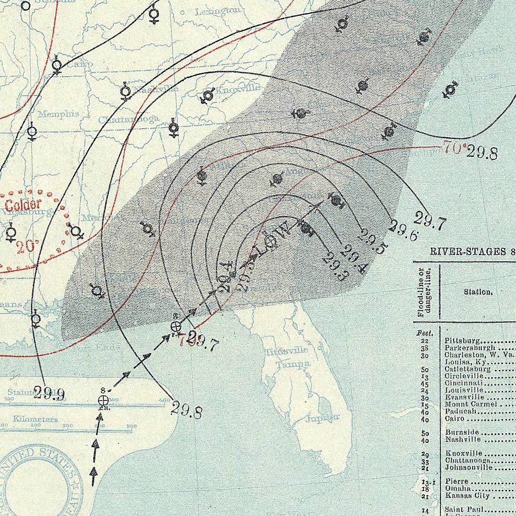
Made landfall today in 1894.
The fifth storm formed on October 1 and lasted until October 12. It formed to the northwest of the Panama Canal, tracked northwest, and struck the Florida Panhandle with winds of 120 mph (190 km/h), equivalent to a major hurricane on the Saffir–Simpson hurricane scale. It tracked through Georgia, South Carolina, North Carolina, Connecticut, Massachusetts, New Hampshire, Maine, and Canada. The hurricane caused about $1,000,000 in damage (1894 USD).
You could, umm, uh huh, oops, like oh, accidentally mash that button right over there. Jes sayin...I'll have to find something to do during the down times.
Shifted back to the west some now. Could be a longer time in the EOC than I hoped.
I wonder if Cantore’s great-grandfather was down at Alligator Point for that one?The Florida Panhandle Hurricane of 1894 Cat 3

Made landfall today in 1894.
The fifth storm formed on October 1 and lasted until October 12. It formed to the northwest of the Panama Canal, tracked northwest, and struck the Florida Panhandle with winds of 120 mph (190 km/h), equivalent to a major hurricane on the Saffir–Simpson hurricane scale. It tracked through Georgia, South Carolina, North Carolina, Connecticut, Massachusetts, New Hampshire, Maine, and Canada. The hurricane caused about $1,000,000 in damage (1894 USD).
Indeed, he arrived on horseback.I wonder if Cantore’s great-grandfather was down at Alligator Point for that one?
The Missus just got a message from our insurance company about how to file a claim. That’s a first and can’t be a good sign 
Where are you located?The Missus just got a message from our insurance company about how to file a claim. That’s a first and can’t be a good sign
Our EOC director wants so badly for this storm to hit Walton County directly. I understand it's situations like this that justifies his job but the dude is wishing it on us. I just told him to stop. The rest of us weren't as eager to be without power.
Kinda Weather Channel, “look at us” ness. I love storms, but do not wish for them to knock people off of their norms. Too many folks in today’s world are barely getting by. We as a society are seemingly OK with less fortunate being vulnerable to basically any disruption throwing them into crisis.Our EOC director wants so badly for this storm to hit Walton County directly. I understand it's situations like this that justifies his job but the dude is wishing it on us. I just told him to stop. The rest of us weren't as eager to be without power.
Truly tho, if I was the only one impacted, I would say “ bring it!”
Watching WU, it appears that the eye may pass directly through Walton/Okaloosa.Kinda Weather Channel, “look at us” ness. I love storms, but do not wish for them to knock people off of their norms. Too many folks in today’s world are barely getting by. We as a society are seemingly OK with less fortunate being vulnerable to basically any disruption throwing them into crisis.
Truly tho, if I was the only one impacted, I would say “ bring it!”
The local weather tiger guy seems to say that if it hits Destin or west we will have Irma like weather. If it’s PC or east could be hermine like. If it’s St Marks could be Kate like.Watching WU, it appears that the eye may pass directly through Walton/Okaloosa.
Unless it's shifted a bunch since the last NWS conference call at 4:45 CDT, Panama City is in the crosshairs.Watching WU, it appears that the eye may pass directly through Walton/Okaloosa.
WU needs to update their respective U.S & Euro models they're currently displaying then.Unless it's shifted a bunch since the last NWS conference call at 4:45 CDT, Panama City is in the crosshairs.
Our EOC director wants so badly for this storm to hit Walton County directly. I understand it's situations like this that justifies his job but the dude is wishing it on us. I just told him to stop. The rest of us weren't as eager to be without power.
Since when did De Funiak Springs get electricity?!
It's only just over half an hour to Vernon...Since when did De Funiak Springs get electricity?!
To clarify, my wife, who got the message, is in Tally. I am currently some 800 miles away in Huntington, WV. I have to supervise some pre-planned work on our house up here and the Missus had an obligation in Tally this past weekend so she stayed home. Gonna be nervous up here watching the storm blow through with her down there. We’ve got friends to help out if it comes to that.#metoo
The path is for it to turn short of getting to Walton and go into Bay. Of course, it could change 5 times before now and Wednesday afternoon.WU needs to update their respective U.S & Euro models they're currently displaying then.
Exactly, we all know these CANES have a mind of their own. I’m not sure what to make of this yet, I only wonder how much stronger Mr. Michael will get. Only fitting he shows up in October with the new Halloween movie coming out.The path is for it to turn short of getting to Walton and go into Bay. Of course, it could change 5 times before now and Wednesday afternoon.
Similar threads
- Replies
- 3
- Views
- 660
Sports Business Department of Education issues "guidance" on NIL
- Replies
- 56
- Views
- 2K
- Replies
- 0
- Views
- 430
- Replies
- 8
- Views
- 2K
ADVERTISEMENT
ADVERTISEMENT

